
[ad_1]
The National Hurricane Center is projecting Beryl to make landfall as a Category 1 hurricane along the lower or middle Texas coast. That’s where it warns of “an increasing risk of damaging hurricane-force winds and life-threatening storm surge.”
In addition, very heavy rains, totaling at least 5 to 10 inches, are projected inland, bringing the threat of flooding. And this system appears prone to produce a few quick-hitting tropical tornadoes, which could affect the greater Houston metro area even if landfall ends up being much farther to the west.
Hurricane watches cover the coast of Texas from just southwest of Galveston Bay to the Texas-Mexico border, and continue in northeastern Mexico as far south as Barra el Mezquital. Storm surge watches also blanket the Texas coastline, stretching northeast of Houston-Galveston all the way to High Island. The predicted surge — or rise in ocean water above normally dry land near the coast — could reach up to 3 to 5 feet.
The Hurricane Center has also issued tropical storm warnings for the Texas coast south of Baffin Bay, which is south of Corpus Christi, to the border with Mexico, where storm conditions will begin first, and said it will probably expand warnings later on Saturday.
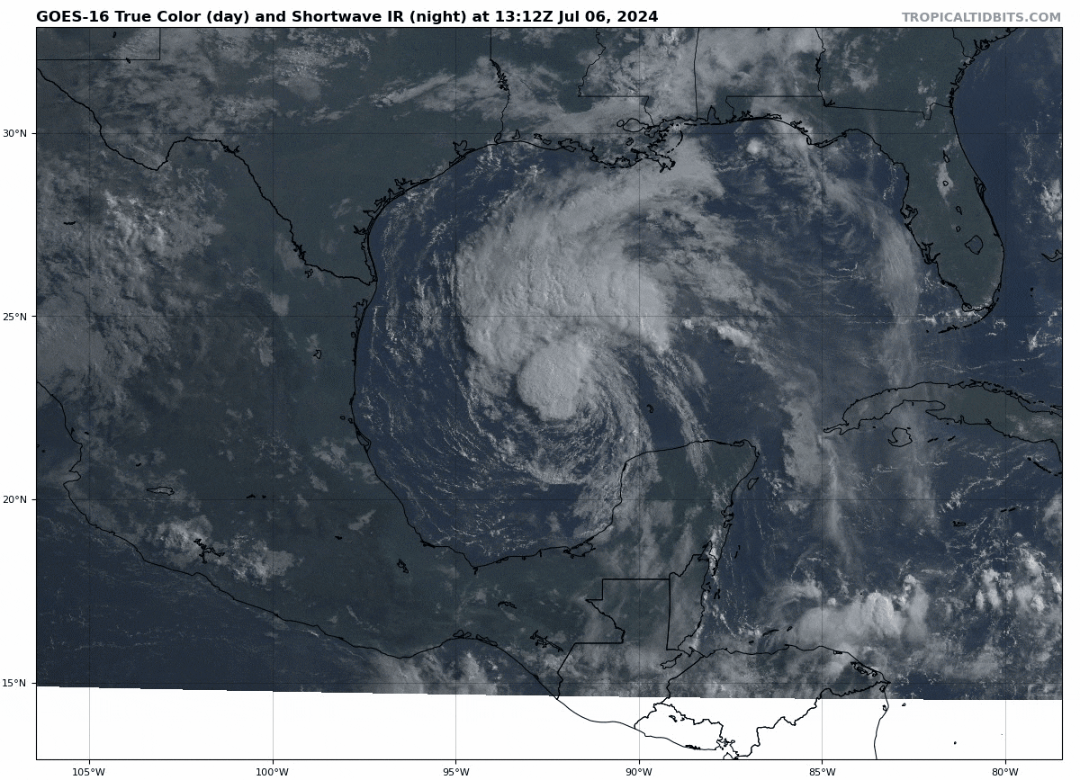
Where is Beryl now and how strong is it?
Beryl was a tropical storm with 60 mph winds Saturday morning, having lost some of its strength and organization after sweeping across the Yucatán Peninsula on Friday following a Category 2 landfall.
As of about 1:30 p.m. Eastern time, its center was located about 390 miles southeast of Corpus Christi. It was moving west-northwest at 12 mph.
Beryl looked quite disorganized on satellite imagery early Saturday, and its low-level and mid-level centers have become misaligned. That means the system is tilted and knocked a bit off-kilter. It won’t be able strengthen markedly until it reorganizes, and forecasters expect that much of Saturday will be spent trying to straighten itself out. The Hurricane Center wrote that conditions should support “significant strengthening” by Sunday morning.
When could impacts begin along the Texas coast?
In far South Texas near Brownsville, rain showers and tropical storm-force winds could arrive as early as midmorning Sunday, spreading north and reaching Corpus Christi during the early to midafternoon and Houston by evening. It’s more likely, however, that most areas won’t see heavy rain and gusty winds until Sunday evening, worsening as the storm approaches into early Monday. Preparations for those at risk should be completed by late Saturday.
Rip current impacts are already beginning, though, meaning it’s imperative to obey signs and flags at beaches, and swim only where lifeguards are present.
The storm surge will probably begin during the day on Sunday, with each tidal cycle becoming higher, and leading to more splash-over and flooding through Monday. The worst surge will be found to the east of where the center makes landfall, since that’s where onshore winds will pile water against the coastline.
Lt. Gov. Dan Patrick (R), who is in charge while Gov. Greg Abbott (R) is on a trade mission in Asia, issued a preemptive disaster declaration for dozens of counties to help provide aid.
How strong will the hurricane become?
Beryl won’t be able to strengthen until it reorganizes. Since most of Saturday will be spent rebuilding itself, the storm won’t have more than Sunday to strengthen.
That said, meteorologists do expect it will intensify right up until the point of landfall on Sunday night or Monday. In fact, the most favorable conditions for strengthening may be found right before it moves ashore. That’s when diffluence, or spreading of air aloft, will enhance upward motion and make it easier for warm, moist air to rise into the storm.
It’s most likely that Beryl will be a Category 1 storm when it moves onto land, but there’s an outside chance it could be a bit stronger or weaker.
What areas will probably be hardest hit?
While subject to change, the city most at risk for serious hurricane impacts appears to be Corpus Christi, especially the north side. The average computer model simulation brings the storm ashore between Corpus Christi and Matagorda. Landfall could end up close to Rockport, which is where Hurricane Harvey came ashore in 2017. Houston isn’t in the clear yet, though, and neither is Brownsville.
Due to dry air wrapping in on the backside of the storm, it’s likely the left, or western, edge of the storm will have a very sharp cutoff. That’s why impacts will vary markedly within only a few miles left of the center. One county may be drenched with rain, and the next one over may hardly end up with an inch.
The heaviest rain will probably occur to the north and east of where the center comes ashore. The Hurricane Center wrote that flooding from heavy rain could be “locally considerable,” with peak amounts up to 15 inches.
Tornadoes will be most likely east of the center in the “feeder bands” spiraling into the storm.
The potential for both tornadoes and heavy rain could persist into midweek as Beryl’s remnants progress inland, possibly extending into southeast Oklahoma and Arkansas and even farther east and north later in the week.
What are the biggest unknowns about this storm?
Meteorologists still aren’t sure where Beryl will come ashore; it could reasonably occur roughly between South Padre Island and Galveston. Moreover, it’s unclear how quickly Beryl will reorganize, and so it’s not clear when the period of strengthening will begin.
Since it’s a race against time before landfall, every hour that passes is an hour that affects the storm’s eventual peak intensity.
Beryl became the first hurricane of the 2024 season and the earliest-forming Category 5 on record in the Atlantic on Monday night. The storm — fueled by record-warm ocean waters — broke benchmarks for its strength and the rate at which it intensified so early in the season, stunning meteorologists.
The storm first hit Grenada, St. Vincent and other Caribbean islands Monday, leaving behind widespread destruction — particularly on the Grenadian islands of Carriacou and Petite Martinique — and killing at least five people. Three additional deaths were reported in Venezuela.
On Carriacou, home to about 7,000 people, the hurricane wreaked “total devastation all around,” said Allison Caton, 50, owner of Paradise Beach Club, a restaurant and bar on Paradise Beach that was destroyed. Many of the island’s residents are now living in makeshift shelters in schools.
On Wednesday, the storm scraped by Jamaica’s southern coast, producing flooding rains and wind gusts over 80 mph that destroyed homes and toppled trees and power lines. At least two deaths were reported, and roughly 65 percent of Jamaica Public Service Co. customers — about 400,000 households — were left without power as of Thursday, the BBC reported.
The storm brought strong winds and heavy rain to the Cayman Islands Wednesday night before barreling toward the Yucatán Peninsula.
Beryl struck the Yucatán as a Category 2 hurricane, toppling trees and power lines and causing widespread blackouts, but no casualties were reported.
Jason Samenow, Amanda Coletta, Kim Bellware and Samantha Schmidt contributed to this report.
[ad_2]
Source link